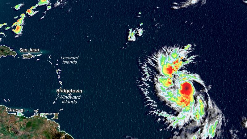
Lee has strengthened into a hurricane as it moves over a record-warm Atlantic, with 75 mph sustained winds, according to a 5 p.m. EDT advisory from the National Hurricane Center.
The warm ocean waters are expected to fuel the storm to near Category-5 strength as it approaches the eastern Caribbean.
Lee was located about 1,130 miles east of the northern Leeward Islands, the center said. It’s too soon to know whether this system will directly impact the US mainland, but even if the hurricane stays off the coast, dangerous surf and rip currents could threaten the Eastern Seaboard.
The storm had rapidly strengthened earlier Wednesday: Its sustained winds strengthened by 35 mph in the 24 hours after it formed as a tropical depression Tuesday morning.
Lee will start to impact the Lesser Antilles – including the Leeward and Windward islands – on Friday, the center said, and the storm is likely to “intensify into an extremely dangerous major hurricane” by early Saturday.
Even more rapid intensification – defined as an increase in wind speeds of at least 35 mph in 24 hours or less – is expected in the coming days. The forecast track takes the hurricane across some of the warmest waters in the Atlantic Ocean and through relatively calm upper-level winds, which will allow Lee to explode in strength.
The waters in the Atlantic are not quite as warm as the steamy conditions in the Gulf of Mexico, which gave rise to Hurricane Idalia last week. However, sea-surface temperatures across the portion of the Atlantic Ocean that Lee is set to track through are still a staggering 2 degrees Celsius (3.6 degrees Fahrenheit) above normal after rising to “far above record levels” this summer, according to David Zierden, Florida’s state climatologist.
Been thinking a lot recently about how unusual the 2023 Atlantic water temps are. Imagine Lee headed into 1983 waters east of the Leeward Islands (27.5C)- 2023 Lee has 29.5C to work with- an astounding difference. Arguably doubles or triples the chance of Rapid Intensification pic.twitter.com/klSy5RhIUy
— Eric Blake (@EricBlake12) September 6, 2023
Swells caused by the hurricane are likely to cause life-threatening surf and rip current conditions in portions of the Lesser Antilles on Friday and are expected to reach the British and US Virgin Islands, as well as Puerto Rico, this weekend.
Lee’s maximum forecast intensity of 150 mph is equivalent to the strongest storm in the Atlantic basin this season – Hurricane Franklin – and stronger than any storm so far in the eastern Pacific. If Lee tops 150 mph, it will be the most powerful hurricane to roam either basin this year.
That forecast is also just 7 mph shy of Category 5.
“This storm definitely has the potential to be a Category 5,” Dunion said, adding that nothing in Lee’s forecast path is expected to hinder the storm’s development leading up to the weekend.
The last Category 5 hurricane to roam the Atlantic basin was 2022’s Hurricane Ian. Before that, 2019’s Dorian and Lorenzo were the most recent hurricanes to achieve the feat. Only 39 Category 5 hurricanes have occurred since 1924, according to data from NOAA.
Any shifts along Lee’s track as it nears the Leeward Islands would increase the threat of more direct impacts like heavy rainfall and strong winds. Anyone in the eastern Caribbean – including the Leeward Islands, Puerto Rico and Hispaniola – as well as the Bahamas will need to keep a close eye on the forecast headed into the weekend.
Lee will ramp up in intensity as the peak of the Atlantic hurricane season approaches. Sunday, September 10, is the climatological peak of Atlantic hurricane season, when the basin is at its busiest on average. A flurry of tropical activity surrounding this date is not out of the ordinary, but it can turn hazardous fast.
The 2023 Atlantic season has already been busy: It is tracking above average for a number of different metrics including number of named storms, number of hurricanes and number of major hurricanes, according to Philip Klotzbach a research scientist at Colorado State University.


