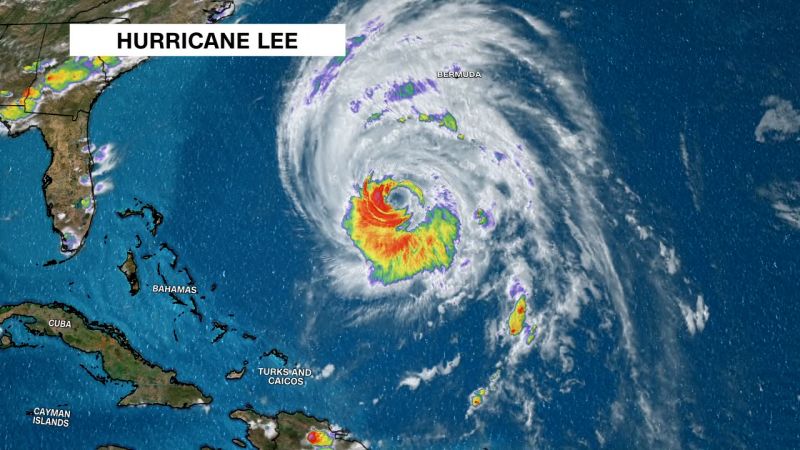
Hurricane Lee, an enormous Category 1 storm whipping strong winds across hundreds of miles, is inching closer to New England and expected to impact the region Friday evening into Saturday.
Lee is so huge that its tropical-storm-force winds (between 39 and 74 mph) extend more than 300 miles from the center – well outside the National Hurricane Center’s forecast cone, which indicates where the center could track.
Though Lee is not expected to make landfall in New England, the storm’s heavy rain could trigger isolated inland flooding, high surf could cause coastal flooding, and powerful wind gusts could knock out electricity.
“We’re going to start to see those direct impacts start to move into portions of southeastern New England as early as later this afternoon, this evening, and then spread northward up into Maine overnight tonight and into Saturday,” National Hurricane Center Director Michael Brennan said Friday.
“The big story with Lee is just that it’s a large hurricane.”
Shadow from Lee cirrus cloud shield is clearly visible at sunrise this morning. #mewx #nhwx pic.twitter.com/0pwhbu7Btl
— NWS Gray (@NWSGray) September 15, 2023
As of 2 p.m. ET Friday, Hurricane Lee was centered about 340 miles south-southeast of Nantucket, Massachusetts, the National Hurricane Center said. It was traveling north-northeast at 18 mph, whipping maximum sustained winds of 80 mph.
“So even though the center is expected to stay offshore of the coast of southeastern New England,” Brennan said, “those tropical-storm-force winds are going to move into places (in Massachusetts) like Cape Cod, Martha’s Vineyard, Nantucket as we get later into today and tonight, and then spread northward along the coast of New England and up into Atlantic Canada overnight tonight and early Saturday.”
Lee’s winds could cause power outages and isolated flooding – especially in areas where the ground is already saturated from recent rain.
“There’s leaves still on the trees in New England. There is wet soil. So there’s going to be the potential for tree damage, power outages,” Brennan said.
At the coast, flooding of 1 to 3 feet above ground level is possible if Lee’s storm surge coincides with high tide from the Long Island Sound north through Maine, Brennan said.
9/15 11am AST: Coastal flooding accompanied by large & destructive waves from Hurricane #Lee is possible along the southern New England coast beginning this afternoon, spreading northward along the coast through Saturday. Please check https://t.co/0BMJEzOTx0 for updates! pic.twitter.com/S0VsJELTru
— NHC Storm Surge (@NHC_Surge) September 15, 2023
Lee will “approach the coast of New England and Atlantic Canada today and Saturday,” the hurricane center said. “Lee is then expected to turn toward the north-northeast and northeast and move across Atlantic Canada Saturday night and Sunday.”
Along the way, Lee could deluge some communities with a combination of rain, storm surge and high tide.
“A dangerous storm surge will produce coastal flooding within the wind warning areas in Atlantic Canada in areas of onshore winds,” the National Hurricane Center said. “Near the coast, the surge will be accompanied by large and destructive waves.”
On Saturday, hurricane-strength winds (at least 74 mph) are possible from the northern coast of Maine into portions of the Canadian provinces of New Brunswick and Nova Scotia. But tropical storm-force wind gusts are possible across a much larger area of New England and Atlantic Canada.
In Canada, Provincial and wildlife parks in Nova Scotia are closed Friday as Lee inches closer to the area.
“Safety is our priority as we prepare for storm conditions forecast for the weekend,” said Tory Rushton, provincial minister of natural resources and renewables. “We are closing our parks for the storm and will reopen when it is safe.”
Lee is expected to dump its heaviest rain – up to 6 inches – over far northern Maine on Saturday. Neighboring New Hampshire, Massachusetts and Rhode Island could also see several inches.
Massachusetts Gov. Maura Healey declared a state of emergency Friday as coastal parts of the state prepared for strong wind, heavy rain and flooding.
And Maine Gov. Janet Mills declared a state of emergency Thursday, requesting federal aid in preparation for the storm’s arrival.


