Hurricane Lee continues to creep toward New England, where hurricane and tropical storm watches have been issued for much of its coastal residents in anticipation of the colossal storm’s possible impact on Friday and through the weekend.
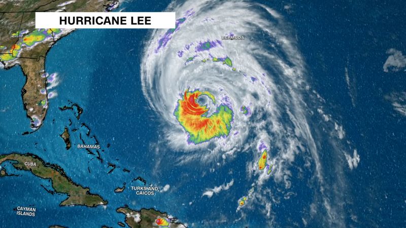
Lee’s winds could begin to buffet portions of New England as early as Friday as the storm’s center is expected to pass close to the region’s southeast before barreling near or over Maine and Atlantic Canada over the weekend as a “large and dangerous cyclone,” according to the National Hurricane Center.
Though the storm – now a Category 2 hurricane – is expected to weaken as it approaches, it will still have a massive radius of damaging winds that will be significantly felt along coastal New England and Canada’s Atlantic provinces.
“Hurricane conditions, heavy rainfall, and coastal flooding are possible in portions of eastern Maine on Saturday,” the National Hurricane Center said. The area is under a hurricane watch, as is parts of New Brunswick and Nova Scotia.
“Life-threatening” storm surge flooding could inundate parts of southeastern Massachusetts late Friday and Saturday, the agency said. A storm surge watch has been issued for the area, including Cape Cod and Nantucket.
A tropical storm watch has also been issued for large swaths of coastal New England, including Nantucket and Martha’s Vineyard, Massachusetts.
Lee was about 295 miles southwest of Bermuda as of 5 a.m. ET Thursday and was churning with maximum sustained winds of up to 100 mph, according to a hurricane center advisory.
The storm is on track to sweep past Bermuda to its west Thursday, prompting an island-wide tropical storm warning.
Even if Lee doesn’t make landfall in New England, the sprawl of its damaging winds means there will be “little to no significance on exactly where the center reaches the coast,” the hurricane center has said.
As of Thursday morning, hurricane-force winds extend up to 105 miles from its center and tropical storm-force winds stretch for up to 290 miles, according to the agency.
And that wind field has only been growing larger, according to National Oceanic and Atmospheric Administration Lt. Commander Josh Rannenberg, who flew through the storm’s eye on Wednesday.
Heavy rainfall could overwhelm already rain-drenched stretches of the Northeast, where saturated ground may be particularly susceptible to flash flooding.
Over the past two weeks, parts of Massachusetts and New Hampshire have been soaked with rainfall levels more than 300% above normal values, according to weather service data. The downpours have already triggered dangerous flooding in areas of Massachusetts and Rhode Island this week.
The softened soil combined with raging winds will also increase the likelihood of downed trees, which in turn could knock out essential power lines and cause outages across the region.


